This work explores what warming winters look like in a community tethered to snow. Reconstructed maps, frozen ink washes, and temporary installations strive to understand Dillon Reservoir’s role in Colorado’s waterways while reflecting the living details that accumulate into an understanding of place. These artworks consider how the visual memory held within water levels, stream banks, and ice structures is shifting. The materials and techniques carefully ask how this narrative combines with our current diversion system, map making tools, and reflections within the community. The actions shaping this work – carving away and sewing together – mirror how earlier snowmelt poses challenges to the existing infrastructure tying together Front Range and mountain communities.
This work explores what warming winters look like in a community tethered to snow…throughout Colorado, reservoirs like Dillon tie together Front Range and Mountain communities.
Art, Science, Place, and Community
Through conversations with Summit High School, Denver Water, The Blue River Watershed Group and A-Basin Ski Area, themes resurfaced: accumulation, melt, freezing, changing scales, interactions between natural and constructed reservoirs, tension and division.
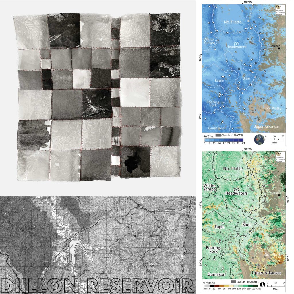
Throughout Colorado, reservoirs like Dillon tie together Front Range and Mountain communities. The actions shaping each piece – carving away and sewing together – mimic the challenges that earlier snowmelt poses to the current reservoir infrastructure. These artworks consider how the visual memory held within water levels, stream banks and ice structures is shifting. Black and white relief prints and frozen ink structures reflect the tree lines and streams I so strongly associated with living here in the Blue River Basin. Red stitches move along the base of lodgepole pine to illustrate the increased melting and changing water levels throughout the year.
The artist gathered with students at Summit High School, adjactent to Dillon Resevoir, for a printmaking workshop to reflect with a younger community on the issues of snowpack and melting trends. Students from all around the Summit County attend the school, symbolizing the convergence of the Snake River, Blue River, and Ten Mile Creek contributions to the reservoir. During the workshop, students carved relief print reductions representing a map of the Snow Water Equivalent within the Blue River Basin. By carving away and printing multiple phases of the same block, students pressed layers of ink together. This accumulation mirrored the process of snow building up over a season and created an image that referenced a water management map.
What you can do to address this issue
High Country Conservation
A hub of resources for Summit County’s Energy and Climate Plans, water conservation methods, recycling and food scrap options and local food. Visit their website to sign up for a home energy audit, learn about ways to save water indoors and much more.
The Blue River Watershed Group
Learn more about the Blue River Watershed and get involved through educational community events in Summit County.
Protect Our Winters
Join a team of outdoor enthusiasts working to drastically curb our emissions by incentivising a clean energy future, prioritizing climate policy and shifting our nation’s attitude towards climate change.
Citizen’s Guide to Where Your Water Comes From
Learn more about how precipitation, climate, rivers and aquifers shape Colorado’s water supply, as well as the distribution and treatment systems that move water throughout the state.
Environmental and Social Issues Explored
This work explores what warming winters look like in a community tethered to snow. Reconstructed maps and frozen ink washes strive to understand and communicate Dillon Reservoir’s role in Colorado’s waterways, as well as the impact of an earlier snowmelt resulting from climate change. Dillon Reservoir sits within the intersection of recreation and natural resource management; the surrounding snowpack feeds the reservoir as well as a continually growing ski and recreation industry in Summit County. Still, the snowpack melting into this scenic body of water is a far more expansive connector of human and ecological life.
The Roberts Tunnel transports water to Denver, passing underneath the Continental Divide to the Front Range. Snowpack that melts earlier in the year and shifts in the steady timing of snowmelt pose challenges to reservoir management. There is less water available in the later summer and fall months when it is needed most. This work combines the tools and data used to manage Dillon Reservoir with the human experience of living next to this constructed body of water.
Science Integrated into the Artwork
The impacts of climate change on water sustainability in Colorado are inherently linked to changes in mountain snow accumulation and snowmelt timing, which sustain agricultural and municipal water demands for the state. The current water management infrastructure is tailored to capture, release and deliver the natural release of spring snowmelt from source areas to demand areas. For example, about 80% of the population in Colorado lives on the Front Range on the east side of the Continental Divide, while about 80% of the state’s source waters are on the Western Slope.
Since the 1930s, trans-basin diversions have moved water from west to east to satisfy the demands of the growing Front Range. The efficiency of this storage and delivery system is greatly enhanced by the storage of winter precipitation in the mountain snowpack and the relatively slow delivery of snowmelt water into the system. Snowpack measurements over the past 50-plus years suggest a broad-scale reduction in snowpack water storage associated with regional warming – a trend that is partly due to a shift toward earlier snowmelt. Projected onto this supply-reduced scenario, the demand for water in the region is escalating as agricultural, industrial, and societal pressures on the current system grow. Furthermore, land-cover changes associated with ex-urban population growth and wildfires have altered the functioning of ecosystems and the availability of water. New snowpack mapping techniques have improved scientific understanding of the climate-snow-ecosystem feedbacks and inform the operational procedures and legal agreements associated with water allocations.

")


The artwork shown above is located in the Colorado State Capitol through October 16, 2023.