How do we see the unseen? The HydroEcologies series explores the hidden story of relationships between groundwater and human impact on climate along the Front Range Urban Corridor. Data of selected wells is transformed into visual narrative using locally sourced materials to address the ongoing drought crisis in the area.
I realized how complex and multilayered “ HydroEcologies, Unseen” is: every single person I talked to either during collaborative community walks or personal encounters, including scientists, well-management teams, teachers, students, and kids had something to share
Art, Science, Place, and Community
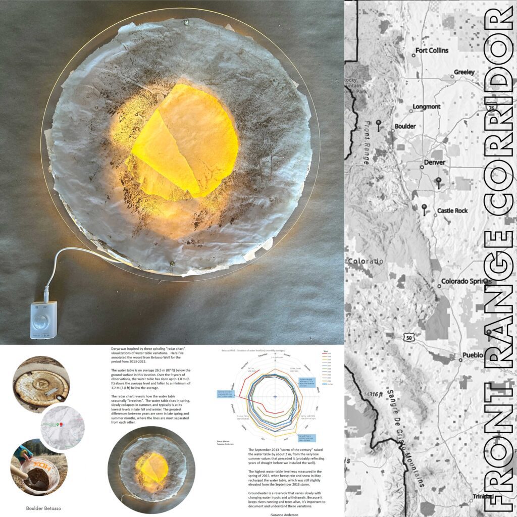
The rise and fall of groundwater levels from month-to-month and year-to-year from select wells in the Denver Water Basin and Front Range Corridor are revealed in the artwork. The sculptures were created, using locally-sourced materials, to further emphasize the impact of drought fueled by climate change and human management of water in Colorado. The paper is partially made from upcycled vellum processed with soil and water from each location. Each sheet of paper corresponds with a specific year and combines data from each designated well. Data is represented by torn edges of each sheet, with lowest water level values radiating from the center. The paper is embedded into the custom made light box. Warm light illuminates the sculpture from within—shedding light onto unseen HydroEcologies of the Colorado Front Range.
As a part of the human – water narrative, walks with local community members to discuss their relationships with water were recorded via GPS tracking and laser-etched into the sculptures. Darya Warner traveled to five front range urban corridor locations to do talks and geolocation walks with different communities to hear the stories and record them via a collective drawing.
Environmental and Social Issues Explored
HydroEcologies is a metaphor for the hidden history of relationships between groundwater and human impact on climate along the Front Range Urban Corridor. People leave traces of impact on the surrounding world that become a part of the unseen story of water.
Science Integrated into the Artwork
Groundwater is an unseen yet important water reservoir that fills and drains with inputs from rain and snowmelt and that discharges out to springs, rivers, or withdrawals from pumping. Groundwater maintains flow in rivers and supports trees during the dry intervals between snowmelt or rain. Water levels decline during periods of drought, whether seasonal or long-term. Extreme events can boost groundwater levels, an effect that persists for months.
We transformed data from select wells into a visual narrative, representing annual variations in water levels, with circular paper forms that bulge and shrink as water levels rise and fall. The paper uses locally sourced materials to address the ongoing drought crisis in the region. Wells were selected for the length of measurement record and proximity to urban areas in or near the Denver Water Basin. We gathered 200 years of monthly measurements from the US Geological Survey, National Ground-Water Monitoring Network, and CU Boulder datasets. The resulting sculptural work provides a complex narrative about the water reservoir hidden beneath our feet. For more information, see here.
What you can do about the issue
This project invites participants to contribute via sharing the insight on groundwater (usage, distribution, information and data availability and other issues). Educate yourself and implement:
- Water rights in your region
- Groundwater data location and accessibility
- Preservation and sustainable usage of water both inside and outside (for example, replacing the grass lawns with more native species adapted for the specific climate
- Create citizen collectives on groundwater monitoring and resources
- Share information with neighbors locally and regionally


")


The artwork shown above is located in the Colorado State Capitol through October 16, 2023